
- Los Angeles is utilizing satellite technology to gain unprecedented perspectives on wildfires.
- Satellites provide high-resolution images that assist in real-time monitoring and analysis of wildfires.
- Companies like Maxar Technologies and Planet Labs are key players in creating wildfire imagery.
- Artificial Intelligence is used to analyze satellite data for predictive modeling of fire spread.
- Technological advancements improve resource allocation and firefighting strategies.
- The integration of satellite technology and AI helps enhance future city planning and resilience.
- These innovations have global implications for mitigating the impacts of natural disasters.
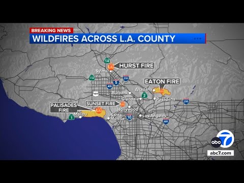
The sprawling cityscape of Los Angeles, known for its vibrant culture and relentless energy, now finds itself in the spotlight for a different reason. Recent innovations in satellite technology have provided unique perspectives on wildfires that recurrently threaten the city.
Satellites Revolutionizing Real-time Monitoring
In the past, tracking the spread and impact of wildfires was reliant on aerial surveys and ground reports. Today, satellites orbiting miles above Earth offer an unprecedented view, aiding firefighters and city planners with real-time data. Companies specializing in satellite imagery, like Maxar Technologies and Planet Labs, are creating high-resolution images that reveal wildfire patterns, damage assessments, and risk predictions.
Predictive Analysis through AI
Emerging technologies are making it possible to employ Artificial Intelligence to analyze satellite data. These advancements allow for predictive modeling of fire spread, helping authorities strategize and allocate resources more efficiently. As AI continues to evolve, it is expected to improve these models, offering greater accuracy and aiding in faster response times.
A Glimpse into the Future
This breakthrough not only benefits immediate fire response but also aids in city planning and resource management. With the ability to understand fire dynamics better, Los Angeles can foster urban landscapes that are more resilient against natural calamities. The broader implications hint at a future where technology collaboration could mitigate the devastating impacts of such natural disasters globally.
In conclusion, as satellite technology and AI continue to merge, Los Angeles sits at the forefront of utilizing these advancements to combat the ever-present threat of wildfires.
How Satellite Innovations are Transforming Wildfire Management in Los Angeles
How does satellite technology enhance wildfire monitoring in Los Angeles?
Recent advancements in satellite technology have revolutionized how Los Angeles monitors its perennial wildfire threats. Companies like Maxar Technologies and Planet Labs have developed high-resolution satellite imagery that provides real-time data on wildfire patterns. This not only assists firefighters with on-the-ground operations but also gives city planners invaluable insights for assessing damage and predicting risks. This real-time data is vital for improving the effectiveness of emergency response and planning urban landscapes resilient against future fires.
What role does Artificial Intelligence play in predictive wildfire modeling?
Artificial Intelligence (AI) significantly enhances predictive modeling by analyzing satellite data to forecast wildfire spread. As AI continues to develop, its integration with satellite imagery provides a more detailed and accurate prediction model. This allows authorities to strategize resource allocation more efficiently and plan quicker response times. For Los Angeles, this means being better prepared to mitigate fire damage and allocate firefighting resources where they are most needed, enhancing overall emergency preparedness.
What are the broader implications of employing satellite and AI technology in wildfire management?
The collaboration of satellite technology and AI in wildfire management extends beyond immediate fire response. For Los Angeles, it means fostering urban landscapes designed to better withstand natural disasters. On a global scale, these technologies could transform how cities worldwide manage wildfire threats, potentially reducing the devastating impacts of such natural calamities. This approach promotes sustainability and improved resource management, helping cities build a more disaster-resilient future.
For more about satellite imagery services, visit Maxar Technologies and Planet Labs.


 Lighting Up Australia’s Night Sky")


